Ensure Your Geospatial Services Are Operational
Geospatial services are designed to be interoperable so it is critical that they remain operational. Our service automatically tests and monitors a majority of Open Geospatial Consortium (OGC) service types. The only thing you need to do to get started is create an account and setup a list of your services to be tested.
Monitor All of Your Geospatial Services
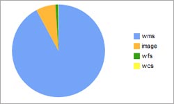
We are always updating the types of geospatial services that we test and monitor. Our current service types include: ArcGIS Map Server, ArcGIS Image Server, ArcGIS Feature Server, WMS, WFS, WCS, SOS, ESRI ArcIMS Image, OPeNDAP, CSW, WAF and Z39.50.
Analyze Geospatial Service Issues & Performance
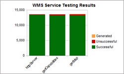
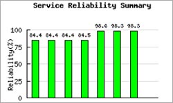
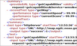
Our comprehensive suite of service tests will provide a rich set of data for your analysis. This data can be used to analyze the issues and determine the best solution.
Use the Control Panel to Maintain Your Geospatial Service Data
The Control Panel allows you to maintain your services to be tested, register for reporting features and create an API key to utilize our developer tools.
Get Alerted of Potential Issues
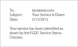
Receive email reports that describe the overall status of your services. You can also receive alert emails when your services are down.
Integrate Service Testing Data with Our Developer API
The service testing data is available so you can integrate it into your own applications. Sign up for an API key and have your developer integrate your service testing results in your geospatial portal, web mapping application or website.